I’ve done one century (100 mile) ride before, but unfortunately Strava only counted it as 99.76 miles. We all know that if it isn’t on Strava, then it didn’t happen, so I felt that I had to rectify this and ride a century recognized by Strava. This time, I would not make the silly mistake of stopping the Apple fitness recording once I hit 100 miles, but would add in a few buffer miles just to be safe.
Okay, that was mostly a joke. The weather was nice, and this was a trip that I’d been planning on doing for a while. I’d even done a scouting trip for it last year. So on one fine early spring day, I set out for my longest ride yet: a 103-mile ride cutting through Western Pennsylvania, a small part of West Virginia, and a bit of Ohio!1
I headed west from my apartment in the middle of Pittsburgh for about 13 miles, until I hit the trail head for the Panhandle Trail. There are a couple of routes you can take here of comparable length; on the way out, I went up Greentree Road. There’s a manageable but nontrivial climb and a small section of highway to contend with, but I prefer this route to passing through downtown Carnegie, where there’s a stop sign or a red light every fifty meters.
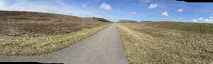
The initial section of the Panhandle Trail is mostly light gravel (crushed limestone, not dissimilar to the Great Allegheny Passage to the south of Pittsburgh). It’s definitely doable on a road bike2, and there are some decent mini-waterfalls by the side of the trail. There are a couple of sections of rough gravel, but I was able to get by on 28mm slick tires.
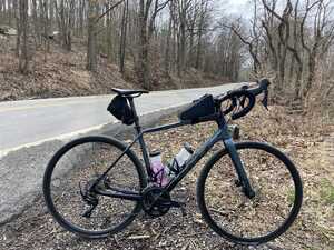
Once you get to McDonald, PA, the Panhandle Trail becomes paved. The trail surface is actually really nice—it’s silky smooth and nicer to ride than some of the Three Rivers Heritage Trail system in Pittsburgh. Out here you start getting into some more rural parts of Western Pennsylvania; I remember this one section that just wound through some really pleasant rolling hills.
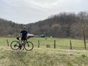
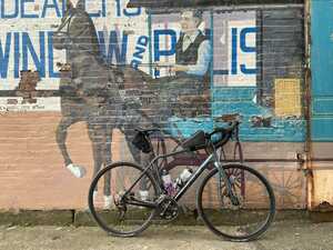
There was a cute little farm that went right up to the trail, with a couple of horses grazing in the field. Seeing that I was trying to get a bike picture, a kind passing cyclist offered to take one for me; you can see the horses in the background. (If you stick around, the horses will actually come up to the fence, but I didn’t want to linger too long, since I still had about 60 miles to go.)
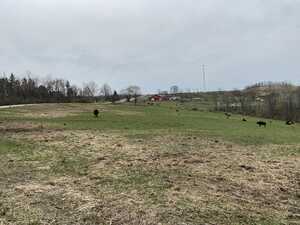
The trail basically continues like this until you get to Weirton, WV. The last three or four miles do turn into gravel, but it’s still manageable on a road bike. When I got to West Virginia, I decided that, having come this far, it would be a shame if I didn’t go the few extra miles to be able to say that I’d gone to Ohio. I got there, but I did not expect the roads between to be so hilly.3 On the plus side, there were some pretty, isolated country roads, and I got a picture of some cows.
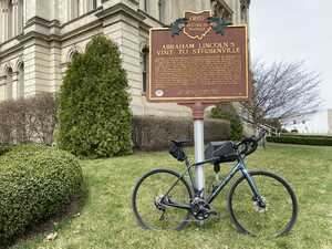
After joining onto a highway for a little while, I finally crossed a bridge over the Ohio River to get into Steubenville, OH. The bridge surface was this interesting metal mesh that felt a lot like riding on cobblestone. I rode around the town for a bit and took some pictures before settling on a bench in front of the Jefferson County Courthouse to enjoy my lunch. As usual, I had a bagel sandwich.4
Perhaps in non-COVID times I would have gone to a local bakery for a nice snack, but unfortunately that will have to wait until another time.
At this point, I’d done a little over 50 miles and hit my destination, so it was time to turn around and head home. I will say that while the trail surface on the Panhandle Trail was a little nicer than the Montour Trail, if you’re planning a century ride, the Montour Trail might be a better choice, since a big loop is usually more fun to ride than an out-and-back again trip.
The way back started out pretty fun, but I quickly started to feel the fatigue. The combination of the most mileage I’d ever done and the most climbing I’d ever done in one ride absolutely demolished my legs. I really enjoyed the beginning of the ride, but by the time I was about 75 miles in, I was just suffering with every pedal stroke. Perhaps it didn’t help that I was going fairly fast (13.8 mph average, and faster on the flat sections) for a ride of that distance and elevation gain, at least for me.
I didn’t really stop for pictures on the way back, since I just wanted to get home as quickly as possible. Despite the gravel riding, I luckily did not get a flat tire, but I did pass one guy with a flat. (This was on the paved section, though.) I offered him a spare inner tube, but it turns out that he was running tubeless tires. I suppose that that’s the downside to all the newfangled technology. I did come prepared with a fresh spare inner tube and one that I had patched from my previous flat tire experience. It actually took me several tries (and many wasted patches) before I finally managed to patch that old tube successfully, but I guess I learned something about bike maintenance.
I managed the flat trail on the way back just fine, but when it came time to get off the trail and head back into Pittsburgh on the roads, I encountered some difficulty. This was the first time I’d ever used my 34-34t gear combination. Despite this, my legs were so dead that I still couldn’t manage to climb this one hill5, and I ended up turning around to take the easier route home through downtown Carnegie, despite the preponderance of stop signs.
Eventually, after some slow riding, my legs recovered a bit, and I was able to get home via my usual route through Junction Hollow, although I seriously did not enjoy the climb on South Neville Street. It’s a very short 7% climb and feels trivial when you’re fresh, but it’s quite painful when you already have 100 miles in your legs.
Overall, it’s nice to be able to say that I’ve ridden to Ohio before, or that I’ve done a century crossing through three states. From a nutrition standpoint, it’s somewhat concerning that I only ate one and a half Clif bars and a bagel. I just got to a point where I felt like I would throw up if I took another bite of a Clif bar. For comparison, the Apple Watch computed that I burned 4,382 kcal during the trip, which is a bit of a frightening calorie deficit. (Perhaps my carb-loading the day before did pay off.) I did treat myself to a nice takeout dinner at Roots that night.
When it comes to the bike, I have to say that the Felt VR performs admirably. It’s fast, fun, and comfortable.6 I’m a fan of the classic round top tube, but I have to admit that the flatter profile on the VR holds a bento box more snugly.7
When it comes to the route, if you have a car, I’d recommend just driving to the trail entrance at McDonald, PA and skipping the initial gravel section of the Panhandle Trail. This also has the advantage of getting you safely out of the city without much climbing on your bike. There’s a cute little shop at McDonald where you can typically find some other trail users congregated. I do not have a car, so I just have to ride out of Pittsburgh.
This was a fun trip. I’m not sure I’d do it in its entirely again (at least alone—perhaps it’d be a fun trip with friends). I think I’ve said this before, but Western Pennsylvania is blessed with a lot of really pleasant riding, but nothing quite as breathtaking as the mountains and ocean vistas of the west coast. It’s not a terrible thing; it’s just a different type of terrain.
Hm, perhaps I should have waited until the next week. Apparently, a few days after my trip, Ohio opened COVID-19 vaccinations to all adults, including non-residents. Meanwhile, Pennsylvania has not.↩︎
And you can pretend that you’re Mathieu van der Poel racing Strade Bianche on the white gravel roads of Tuscany…↩︎
The Panhandle Trail, like most rail trails, is exceptionally flat—I think there’s maybe a 1% grade. However, the roads connecting to it on either side are somewhat hilly.↩︎
This time, I tried Whole Foods bagels. They were actually pretty good; I enjoyed the taste, although I’m not sure that cold bagels will ever have a particularly nice texture.↩︎
In all fairness, I looked on Strava, and that section was like a 24% grade.↩︎
Well, your rear end will always be a little sore after 7 hours in the saddle, but it’s about as comfortable as you’ll get.↩︎
It also helps not to have your stem slammed.↩︎
Comments